


As a window of rare, extreme weather approaches Mississippi this weekend, officials at the National Weather Service are urging residents to ensure they’re aware of rapidly-changing conditions and have a way to receive regular updates.
Forecasters expect a significant outbreak of tornadoes across the Gulf States and Tennessee Valley on Saturday, with the highest risk beginning in the late morning to early afternoon.
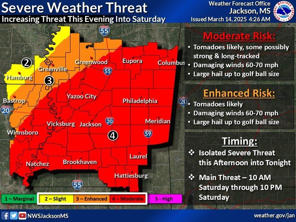
The NWS expects many of those tornadoes will be significant, with long-tracks and potentially violent winds, and damage spread across the region into Saturday night and early Sunday morning.
A moderate risk area for the night of Friday, March 14 has also recently been expanded to include a portion of northern Mississippi, along the border with Tennessee, and is expected to be at its most dangerous in the overnight hours with elevated risk of tornadoes and hail.
But the weather moving across the southeast is not doing so in the manner it usually does. Rather than one long, multi-state line of storms spread across the region, forecasters expect the extreme weather will be scattered and popping up more or less randomly.
“That's probably about the best way we can describe it. There's going to be increasing ingredients for severe weather, including instability and deep layer wind shear and moisture, but the storms may be pretty isolated to begin with,” said Eric Carpenter, a meteorologist at the National Weather Service in Jackson.
“We're not very certain with how things are going to go tonight. We want folks to be aware that there's a threat for severe weather. But as of now, the greater severe weather threat is kind of keying in on Saturday.”
According to the NWS’ Storm Prediction Center, this weekend is only the third time since 2006, the furthest records go back, that a ‘High Risk’ warning has been issued on day two, or two days out from when the severe weather is expected.
Typically, such stark warnings coincide with shorter-range forecasts that fall much closer to the expected period of severe weather.
That’s why Carpenter and many other meteorologists are urging residents across the southeast, but especially in Mississippi and Alabama, to stay up to date with rapidly changing conditions and developing extreme weather.
“That would include damaging winds, large hail, and tornadoes. The tornado threat is especially concerning, especially as you go into Saturday. There is a possibility of getting strong tornadoes, and some of these could be long-track tornadoes. This looks like a pretty significant event in terms of the different severe weather types,” he said.
But the severe weather comes at a time when staffing numbers at the NWS and other government-run meteorological stations are significantly reduced, most of them due to hiring freezes, budget shortfalls and the firing of workers ordered by President Donald Trump’s Department of Government Efficiency, or DOGE.